Geography
Located in the South-west of the Indian Ocean lthe island is elliptic in form, its greatest diameter measures 43 miles (70) km with a surface area of 1555 miles (2512 km²). The island is 39 miles (63 kilometers) long, is 28 miles (45 kilometers) wide. Reunion lies at 21°06' South and 55°32' East, which locates it to the North of the tropic of Capricorn. It is 700 km from Madagscar to the West and 180 km from Mauritius to the North-east.. In the context of the Western Indian Ocean, the submarine plateau of the Mascareignes constitutes the area North to the Seychelles with Mauritius, delimiting the trench of the Mascareignes to the West (-4000 to -5000 m), and that of Madagascar/Maurice in the South (-4000 with -5000m) and to Rodrigues in the East (-5000 m). On Réunion, the coral reefs are very localised covering part of the Western littoral. The lack of a continental shelf means that the sea quickly becomes deep not far from the coast
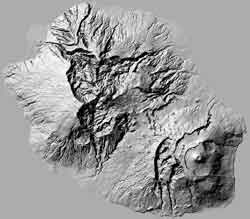
Reunion island is the result of volcanic activity which begun around five million years ago. Lava erupted from a hot spot in the oceanic crust to form a huge cone rather like a worm cast. It is thought that the "island" eventually emerged from the sea around three million years ago and gradually, with succesive eruptions and much erosion became the island that is still evolving today.. Two million years later, the first volcanis mass the Piton des Neiges was formed. Deep under the ocean the "volcano" forms an immense cone with a base of 200km and a total height of about 7000m. The island, being located above a hot-spot in the Earth's crust, is slowly, and impercetibly, moving. It is made up of two distinct volcanoes - the Piton des Neiges (Snow Peak) which is now extinct and the younger and more active Piton de la Fournaise (Furnace Peak)